

The Portuguese India armadas (armadas da Índia) were the fleets of ships, organized by the Portuguese crown and dispatched on an annual basis from Portugal to India, principally Goa. These armadas undertook what was called the Carreira da Índia (“India Run”), following the sea route around the Cape of Good Hope opened up by Vasco da Gama in 1497–1499.
For a long time after its discovery by Vasco da Gama in 1497–1499, the sea route to India via the Cape of Good Hope was dominated by the Portuguese India armada – the annual fleet dispatched from Portugal to India. Between 1497 and 1650, there were 1033 departures of ships at Lisbon for the Carreira da Índia (“India Run”).
Timing
Each leg of the voyage took approximately six months. The critical determinant of the timing was the monsoon winds of the Indian Ocean. The monsoon was a southwesterly wind (i.e. blew from East Africa to India) in the Summer (between May and September) and then abruptly reversed itself and became a northeasterly (from India to Africa) in the Winter (between October and April). The ideal timing was to catch the late summer monsoon to India, and return with the early winter monsoon, minimizing the time at sea.
The India armada typically left Lisbon in the early Spring (March–April). That would bring it to the Cape of Good Hope around June–July, and to the East Africanmiddle coast by August, just in time to catch the summer monsoon winds to India. Arrival in India was usually around early September. The return trip from India would typically begin in January, taking the winter monsoon across the Indian Ocean and down East Africa, double the Cape in reverse around April, and arrive in Lisbon by the Summer (June–August). Overall, the round trip took a little over a year.
The critical step was ensuring the armada reached East Africa on time. Ships that failed to reach the equator latitude on the East African coast by late August would be stuck in Africa and have to wait until next Spring to undertake an Indian Ocean crossing. And then they would have to wait in India until the Winter to begin their return. So any delay in East Africa during those critical few weeks of August could end up adding an entire extra year to a ship’s journey.
The circumnavigation of Madagascar opened an alternative route to get to India, which gave more flexibility in timing. The rule that quickly emerged was that if an outbound armada doubled the Cape of Good Hope before mid-July, then it should follow the old “inner route” – that is, sail into the Mozambique Channel, up the East African coast until the equator latitude (around Malindi, Seychelles), then take the southwesterly monsoon across the ocean to India. If, however, the armada doubled the Cape after mid-July, then it was obliged to sail the “outer route” – that is, strike out straight east from South Africa, go under the southern tip of Madagascar, and then turn up from there, taking a northerly path through the Mascarenes islands, across the open ocean to India. While the outer route did not have the support of African staging posts and important watering stops, it sidestepped sailing directly against the post-summer monsoon.
Arrival times in Portugal varied, usually between mid-June and late August. It was customary for return fleets to send their fastest ship ahead to announce the results in Lisbon, before the rest of the fleet arrived later that summer.
Because of the timing, an armada had to leave Lisbon (February–April) before the previous year’s armada returned (June–August). To get news of the latest developments in India, the outgoing armada relied on notes and reports left along the way at various African staging posts by the returning fleet.
Outward voyage
Portuguese India armadas tended to follow the same outward route. There were several staging posts along the route of India Run that were repeatedly used.
Setting out from Lisbon (February–April), India-bound naus took the easy Canary Current straight southwest to the Canary Islands. The islands were owned by Castile and so this was not a usual watering stop for the Portuguese India naus, except in emergencies.
The first real obstacle on the route was the Cape Verde peninsula (Cap-Vert, Senegal), around which the Canary current ends and the equatorial drift begins. Although not difficult to double, it was a concentration point of sudden storms and tropical cyclones, so ships were frequently damaged. (see Cape Verde-type hurricane)
The Cape Verde islands, to the west of Cape Verde peninsula was the usual first stop for India ships. Relative scarcity of water and supplies on the islands made this a suboptimal stop. Nonetheless, the islands (esp.Santiago) served as a harbor against storms and was frequently a pre-arranged point for the collection and repair of tempest-tossed ships.
The Angra de Bezeguiche (Bay of Dakar, Senegal) was a common watering stop for ships after doubling Cape Verde. The shores were controlled by Wolof and Serer kingdoms, whose relations with the Portuguese were ambivalent, so a warm reception on the mainland could not always be counted on. In the middle of the bay was the island of Gorée (ilha de Bezeguiche), a safe anchoring spot, but the island itself lacked drinkable water. As a result ships frequently watered and repaired at certain mainland points along the Petite Côte of Senegal shore such as Rio Fresco (now Rufisque) and Porto de Ale (now Saly-Portudal). It was not unheard of for India naus to water much further south, e.g. among the many inlets and islands (e.g. Bissagos) along the African coast to Serra Leoa (Sierra Leone).
Below Cape Verde, around the latitudes of Sierra Leone, begin the Atlantic doldrums — that is a calm low pressure region on either side of the equator with little or no winds. At this time of year, the doldrums belt usually ranged between 5° N and 5° S. [N 4] In the southern hemisphere, below the doldrums, was the counter-clockwise gyre of the South Atlantic and the southeasterly trade winds, which prevented sailing directly southeast to the Cape.
Passing the doldrums was a navigational challenge, and pilots had to avail themselves deftly of the currents and every little breeze they could get to stay on course. The usual tactic was to proceed south or even southeast along the West African coast as long as possible, until the doldrums hit (usually around Sierra Leone), then to strike southwest sharply, drift over the doldrums and then catch the South Equatorial Current(top arm of the South Atlantic gyre) towards the coast of Brazil. This was usually referred to as following the volta do mar (literally,’turn of the sea’, i.e. the South Atlantic gyre).
The volta do mar was usually contrasted to the rota da Mina (Mina route). The latter meant striking southeast in the doldrums to catch theEquatorial Counter Current (or ‘Guinea Current’) east into the Gulf of Guinea. This was the usual route to the fort of São Jorge da Mina on the Portuguese Gold Coast. This was not part of the India run. The route from Mina down to South Africa involved tacking against the southeasterly trade winds and the contrary Benguela Current, a particularly tiresome task for heavy square rigged carracks. However, it sometimes happened that by poor piloting, India naus would be inadvertently caught by the Guinea counter-current and forced to take that route, but such ships would not be likely to reach India that year.
Assuming the India armada successfully caught the south equatorial current of the volta do mar, the armada would drift southwest through the doldrums and reach the southbound Brazil Current off the coast of Brazil (around Pernambuco). Although India naus did not usually stop in Brazil, it was not unheard of to put in a brief watering stop at Cape Santo Agostinho (Pernambuco, Brazil), especially if the southeasterly trade winds were particularly strong (pilots had to be careful not to allow themselves to be caught and driven backwards).
From the environs of Pernambuco, the India naus sailed straight south along the Brazil Current, until about the latitude of the Tropic of Capricorn, visibly the Abrolhos islands or the Trindade and Martim Vaz islands, where they began to catch more favorable prevailingwesterlies. These would take them quickly straight east, across the South Atlantic, to South Africa.
The Cape of Good Hope – once aptly named the ‘cape of storms’ – was a very challenging headland on the India Run. The outbound crossing was always difficult, and many a ship was lost here. Larger armadas often broke up into smaller squadrons to attempt the crossing, and would re-collect only on the other side – indeed quite far on the other side. There was usually no stop or collection point after the Cape crossing until well inside the Mozambique Channel. The reason for this is that outbound ships tried to steer clear from the South African coast, to avoid the rushing waters of the contrary Agulhas Current.
The exception was the Agoada de São Brás (Mossel Bay, South Africa), a watering stop after the Cape. It was not always used on the outbound journey since individual ships often charted wide routes around the Cape, and sighted coast again only well after this point. However, ships damaged during the crossing frequently had no choice but to put in there for emergency repairs. Trade for food supplies with the pastoralKhoikhoi peoples that lived in the area was frequent (although there were also occasional skirmishes). São Brás was a more frequent stop on the return journey, as a place to repair the ships to tip-top shape before doubling the Cape the other way. As a result, particularly in early years, São Brás was used as a postal station, where messages from the returning armadas would be left for the outward armadas, reporting on the latest conditions in India.
If the armada went by the ‘inner route’, then the next daunting obstacle was Cape Correntes, at the entrance of the Mozambique Channel. Treacherously fast waters, light winds alternating with unpredictably violent gusts, and treacherous shoals and rocks made this cape particularly dangerous. It is estimated that nearly 30% of all ships lost on the India Run, capsized or ran aground around here, more than any other place.
The ideal passage through the Mozambique Channel would be to sail straight north through the middle of the channel, where a steady favorable wind could be relied upon at this season. But this was a particularly hard task in an era where longitude was determined largely by dead reckoning. If a pilot miscalculated and charted a course too close to the African coast, the current ran south, the winds were light or non-existent, subject to arbitrary gusts from strange directions and the coasts littered with shoals. Into this dreaded mix, Cape Correntes added its own special terror to the experience. The Cape was not only a confluence point of opposing winds, creating unpredictable whirlwinds, it also produced a strange and extraordinarily fast southerly current, violent enough to break a badly-sewn ship, and confusing enough to throw all reckoning out the window and lure pilots into grievous errors.
The temptation would be to err in the opposite direction, and keep on pushing east until the island of Madagascar was sighted, then move up the channel (the current here ran north), keeping the Madagascar coast in sight at all times. Although a Madagascar-hugging route cleared up the longitude problem, it was also abundant in fearful obstacles – coral islets, atolls, shoals, protruding rocks, submerged reefs, made for a particularly nerve-wracking experience to navigate, especially at night or in bad weather.
To avoid the worst consequences of doubling Cape Correntes, India ships stayed as far from the African coast as possible but not so close to Madagascar to run into its traps. To find the ideal middle route through the channel, pilots tended to rely on two dangerous longitude markers—the Bassas da India and the Europa rocks. Although conveniently situated in the middle of the channel, they were not always visible above the waves, so sailors often watched for hovering clusters of seabirds, which colonized these rocks, as an indicator of their location. Unfortunately, this was not a reliable method, and many an India ship ended up crashing on those rocks.
If they succeeded sailing up the middle channel, the India naus usually saw African coast again only around the bend of Angoche. If the ships were in a bad shape, they could stop at the Primeiras Islands (off Angoche) for urgent repairs. The Primeiras are a long row of uninhabited low coral islets – not much more than mounds above the waves – but they form a channel of calm waters between themselves and the mainland, a useful shelter for troubled ships.
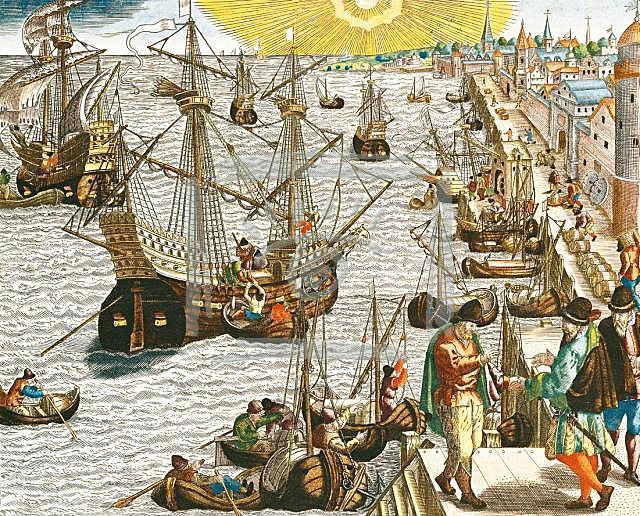
The scheduled stop was a little further north on Mozambique Island, a coral island off the coast, with two outlying smaller islands (São Jorge and Sant’ Iago). Mozambique’s main attribute was its splendid harbor, that served as the usual first stop and collection point of Portuguese India armadas after the crossing of the Cape of Good Hope. The island had a town and a fortress, so some stock of supplies was usually at hand.
The conditions of the ships by the time they reached Mozambique was often quite woeful. Notice that with the occasional exception of Cape Santo Agostinho and Mossel Bay, there are no stops between Cape Verde and Mozambique Island, an extraordinarily long time for 16th-century ships to remain at sea without repairs, watering or resupply. Already before the Cape, provisions had grown stale, scurvy and dysentery had often set in, and deaths of crews and passengers from disease had begun. The ship itself, so long at sea without re-caulking or re-painting, was in a fragile state. To then force the miserable ship through the mast-cracking tempests of Cape of Good Hope, the seam-ripping violent waters of Cape Correntes and the treacherous rocks of the channel, turned this final stage into a veritable hell for all aboard.
Mozambique Island was originally an outpost of the Kilwa Sultanate, a collection of Muslim Swahili cities along the East African coast, centered at Kilwa, that formed a Medieval commercial empire from Cape Correntes in the south to the Somali borderlands in the north, what is sometimes called the “Swahili Coast”. The Kilwa Sultanate began disintegrating into independent city-states around the time of the Portuguese arrival (1500), a process speeded along by the intrigues and interventions of Portuguese captains.
The original object of Portuguese attentions had been the southerly Swahili city of Sofala, the main outlet of the Monomatapa gold trade, and the first Portuguese fortress in East Africa was erected there in 1505 (Fort São Caetano de Sofala). But Sofala’s harbor was marred by a long moving sandbank and hazardous shoals, making it quite unsuitable as a stop for the India armadas. So in 1507, the 9th Armada seized Mozambique Island and erected a fortress there (Fort São Gabriel, later replaced by Fort São Sebastião in 1558), simply because its spacious and well-sheltered harbor was so much more preferable.
The principal drawback was that Mozambique Island was parched and infertile. It produced practically nothing locally, it even had to ferry drinkable water by boat from elsewhere.[10] Replenishing the islands was not a simple matter. Although Mozambique islanders had established watering holes, gardens and coconut palm groves (essential for timber) just across on the mainland (at Cabaceira inlet), the Bantu inhabitants of the area were generally hostile to both the Swahili and the Portuguese, and often prevented the collection of supplies. So ensuring Mozambique had sufficient supplies presented its own challenges. The Portuguesefactors in Mozambique had to ensure enough supplies were shipped in from other points on the East African coast to Mozambique Island before the armada’s scheduled arrival. The Mozambican factor also collected East African trade goods that could be picked up by the armadas and sold profitably in Indian markets – notably gold, ivory, copper, pearls and coral.
After Mozambique, the rule for the India armadas was generally to continue sailing north until they reached the equator latitude (the Seychelles islands, at 4ºS, were a common reference point). It was around here that the all-important southwesterly monsoon winds began to pick up. The armada would then just sail east, and let the monsoon carry them headlong across the Indian Ocean until India. That is presuming the armada arrived at the equator sometime in August.
In Pimentel’s (1746) estimation, ships must leave Mozambique before August 25 to avail themselves of the summer monsoon. If, however, the armada arrived in the latter part of the season, say September, turning at the equator was a risky route. The southwesterly monsoon may be blowing in the right direction at the moment, but the ship ran the risk of not reaching a safe Indian port before the monsoon reversed direction (usually around late September to early October, when it became a northeasterly). So a late season ship was usually stuck in Africa until next April.
Notice that the trajectory, as described, skips over nearly all the towns on the East African coast north of Mozambique – Kilwa (Quíloa), Zanzibar, Mombasa(Mombaça), Malindi (Melinde), Barawa (Brava), Mogadishu (Magadoxo), etc. This is not to say Portuguese did not visit those locations – indeed, some even had Portuguese factories and forts (e.g. Fort Santiago in Kilwa, held from 1505 to 1512). But Portuguese armadas on their way to India did not have to stop at those locations, and so usually did not. The stop on Mozambique island was usually the only necessary one.
Malindi’s other advantage was that, at 3º15’S, it was practically at exactly the right latitude to catch the southwesterly monsoon for an Indian Ocean crossing. Plenty of experienced Indian Ocean pilots — Swahili, Arab or Gujurati — could be found in the city, and Malindi was likely to have the latest news from across the sea. So it was a very convenient stop for the Portuguese before a crossing. However, stops take time. Given the imminent monsoon reversal, that was a scarce commodity. So if the armada had been decently equipped enough at Mozambique island, a stop at Malindi, however delightful or useful, was a rather unnecessary and risky expenditure of time.
With the monsoon, Portuguese India armadas usually arrived in India in early September (sometimes late August). Because of the wind pattern, they usually made landfall around Anjediva island (Angediva). From there, the armada furled their square sails and proceed with lateen sails south along the Malabar coast of India to the city of Cochin (Cochim, Kochi) in Kerala. Cochin was the principal spice port accessible to the Portuguese, it had the earliest Portuguese factory and fort in India, and served as the headquarters of Portuguese government and operations in India for the first decades. However, this changed after the Portuguese conquest of Goa in 1510. The capture of Goa had been largely motivated by the desire to find a replacement for Anjediva as the first anchoring point for the armadas. Anjediva had proven itself to be far from ideal. The island was generally undersupplied – it contained only a few fishing villages – but the armada ships were often forced to sojourn there for long periods, usually for repair or to await for better winds to carry them down to Cochin. Anjediva island also lay in precarious pirate-infested waters, on the warring frontier between Muslim Bijapur and Hindu Vijaynagar, which frequently threatened it. The same winds which carried the armada down to Cochin prevented Portuguese squads from Cochin racing up to rescue it. The Portuguese had tried setting up a fort in Anjediva, but it was captured and dismantled by forces on behalf of Bijapur. As a result, the Portuguese governor Afonso de Albuquerque decided the nearby island-city of Goa was preferable and forcibly seized it in 1510. Thereafter Goa, with its better harbor and greater supply base, served as the first anchorage point of Portuguese armadas upon arriving in India. Although Cochin, with its important spice markets, remained the ultimate destination, and was still the official Portuguese headquarters in India until the 1530s, Goa was more favorably located relative to Indian Ocean wind patterns and served as its military-naval center. The docks of Goa were soon producing their own carracks for the India run back to Portugal and for runs to further points east.
You must be logged in to post a comment Login